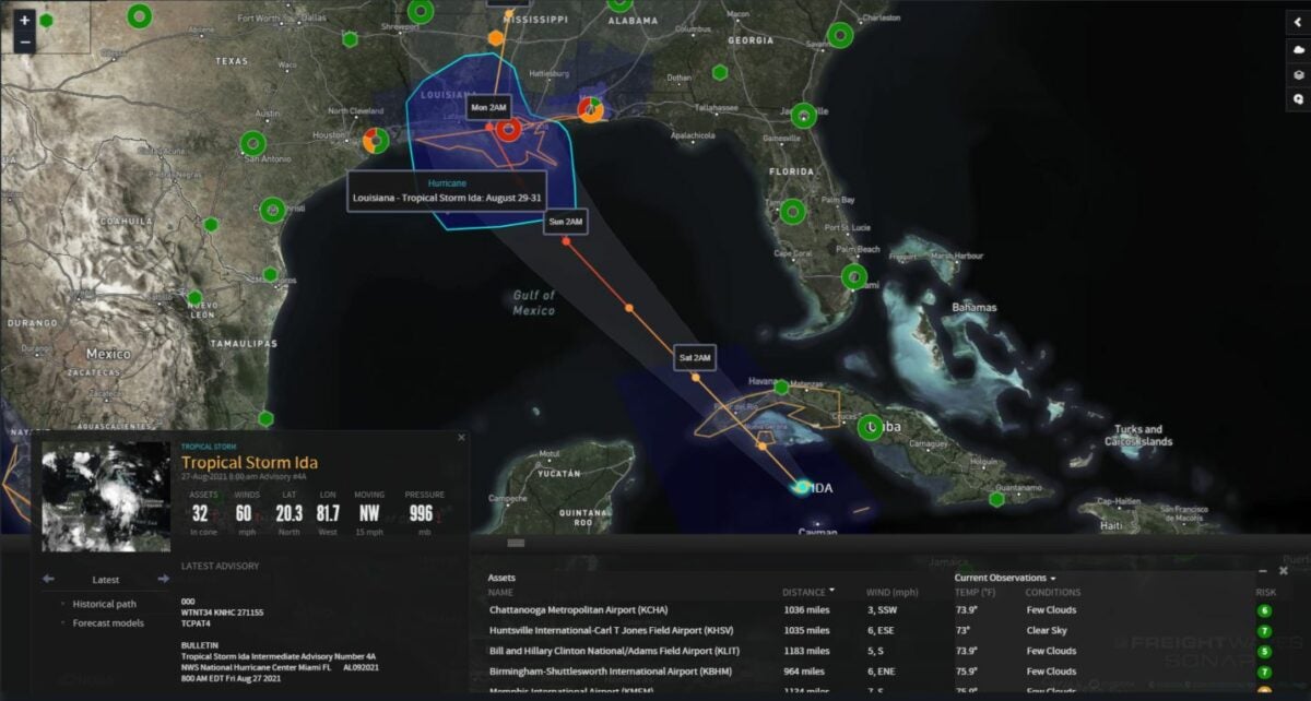
It started as a relatively harmless cluster of thunderstorms in the southern Caribbean Sea earlier this week. By late Thursday afternoon, it became Tropical Storm Ida. By Sunday, it could be a major hurricane as it approaches the northern U.S. Gulf Coast.
Now is the time for carriers to grab as many loads in the potential impact zone as possible before the weather gets too dangerous over the weekend. Also, be ready to help with recovery and rebuilding if and when the Federal Motor Carrier Safety Administration waives hours-of-service rules.
Related: Long view: Preparing logistically for extreme weather
As of 8 a.m. Friday, Ida was centered 75 miles northwest of Grand Cayman. Maximum sustained winds had increased to 60 mph, with higher gusts. Tropical storm-force winds extended outward up to 80 miles from the center.
After Ida crosses western Cuba Friday night, the National Hurricane Center expects it to rapidly intensify into a hurricane Saturday. Extremely warm waters, along with weak wind shear, will provide a favorable environment for Ida to become stronger and better organized as it approaches the U.S.
By early Sunday afternoon, just prior to landfall, Ida could reach major Category 3 hurricane status, with sustained winds of 111 to 129 mph. This would eerily coincide with the 16th anniversary of Hurricane Katrina’s devastating landfall in Louisiana.
Based on the NHC’s latest forecast, landfall will occur somewhere on the Louisiana coast, possibly in New Orleans. However, the margin of error shows landfall could occur as far west as the Louisiana-Texas line, or in southern Mississippi.
The NHC has issued a hurricane watch for Cameron, Louisiana, to the Mississippi-Alabama border, as well as the Lake Pontchartrain, Lake Maurepas and metropolitan New Orleans areas.

A tropical storm watch is in effect from the Mississippi-Alabama border to the Alabama-Florida border. A storm surge watch is in place from Sabine Pass, Texas, to the Alabama-Florida border, in addition to the Vermilion Bay, Lake Borgne, Lake Pontchartrain, Lake Maurepas and Mobile Bay areas.
These watches should be taken seriously and will probably be upgraded to warnings as Ida progresses toward landfall.
As of early Friday morning, all Gulf Coast ports were open, with only light restrictions on commercial vessels in a few places. However, the Coast Guard may tighten restrictions over the weekend.
Tropical storm conditions will begin Saturday evening from southern Louisiana to western Florida, with winds, storm surge and rainfall strengthening Saturday night and Sunday prior to landfall. The initial forecast has the biggest storm surge of 7 to 11 feet slamming areas from Morgan City, Louisiana, to Ocean Springs, Mississippi. Some areas of the Gulf Coast could receive 10 inches or more of rainfall. Life-threatening flooding is likely.
Lanes of concern
Interstate 10 from Beaumont, Texas, to Pensacola, Florida
Interstate 59 from Hattiesburg, Mississippi, to New Orleans
Interstate 65 from Montgomery to Mobile, Alabama
Interstate 55 from Jackson, Mississippi, to New Orleans
Related: Logistics groups ready to help during potentially busy hurricane season
This is a developing story, so look for updates on the FreightWaves website and social media accounts.
Click here for more FreightWaves articles by Nick Austin.
You might also like:
Ferocious California wildfire spreading toward Lake Tahoe
Top 5 US spots for truck-animal collisions
Hot Shots: Fierce fires, ferocious floods, train derailments and more
