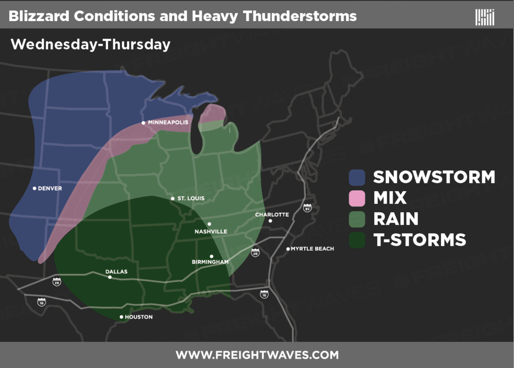
Another winter storm is cranking up and will spread snow for thousands of miles from New Mexico to the upper peninsula of Michigan for at least the next couple of days, from this afternoon through Thursday night. The snowfall will be heavy in some areas, and gusty winds will make travel even more difficult for truckers going back to work and for people driving or flying home from their Christmas vacations.
Earlier this month, AAA predicted that more Americans would travel by car this holiday season than ever before. The 102.1 million people expected to pack up their cars for road trips is 4.4 percent higher than last year, and it’s the most since AAA began tracking holiday travel in 2001. Through the rest of this week a lot of these people will be crowding highways and byways, heading back to their everyday lives. AAA also projected that 6.7 million people would travel by air this year. This is the highest level in 15 years and is 4.2 percent more than last year.
Winter Storm Warnings have been issued by the National Weather Service for eastern Colorado and western Kansas all the way to the Dakotas, Minnesota, and northern Wisconsin. Eight to 15 inches of snow could fall within much of the Warning area. To make matters worse, crosswinds of 40 to 50 mph will make it difficult to deadhead or haul light loads. Drivers will have to allow lots of extra time and take breaks during periods of limited or zero visibility due to blizzard conditions and blowing snow.

Pockets of sleet and freezing rain are possible in the pink-shaded area on the map above, with ice accumulations of up to a quarter-inch. This could make travel even more treacherous on portions of I-29, I-70, I-80, I-90, and I-94. Flight delays and/or cancellations can’t be ruled out across the Midwest and Mountain Prairie regions, affecting major airports like Denver International (ICAO code: DEN) and Minneapolis-St. Paul International (ICAO code: MSP), as well as smaller airports in between.
On the warm side of the storm, look for thunderstorms and heavy rain from Texas, Oklahoma, and Arkansas eastward to Alabama and Tennessee. Severe storms could produce very gusty winds and isolated tornadoes today and tonight from Austin and San Antonio to areas between Dallas and Houston. This could also happen on Thursday in parts of Louisiana. Localized flash flooding across the Gulf Coast states could lead to roadblocks on secondary routes off portions of I-10, I-20, I-24, I-35, and I-40.
The FreightWaves staff hopes everyone had a wonderful and very merry Christmas. Please travel safely!
