The steady stream of heavy rain the past several days across central Texas is fading a bit, but more flooding is possible and river levels are being managed.

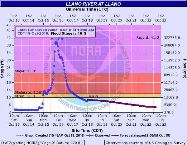
Kingsland, about 50 miles northwest of Austin, is one of the areas hit the hardest. Some people who live there have lost everything. The town lies on the banks of the Llano River which swelled almost 30 feet in 24 hours. By Tuesday morning it was close to the record flood stage of 41.5, feet based on the gauge at the town of Llano, about 15 miles upstream. The water rose so high and was moving so fast toward Kingsland that it washed out the FM 2900 bridge which crosses the Llano River and LBJ Lake.
According to WXAN-TV, a woman’s body was found on Tuesday along the Colorado River between Kingsland and Granite Shoals. On Wednesday a body of an adult woman was found near a low water crossing in Llano, about 15 miles upstream from Kingsland. The bodies of three men who may have died in the flood waters have also been found.
Meteorologists at the National Weather Service office in Austin/San Antonio aren’t calling for non-stop rain the next few days, but occasional showers are in the forecast and could be heavy at times. Any more rain falling onto the saturated soils will lead to excess runoff which could cause more flooding, especially near creeks, streams, and smaller rivers.
In order to better control the river levels, the Lower Colorado River Authority LCRA) opened eight flood gates at Buchanan Dam on Wednesday. This is about 5.5 miles north of Kingsland. Lake Buchanan is 97% full, but LCRA doesn’t expect it to rise today.
Lake Travis is at its highest level in 11 years, its fifth-highest level on record, is 140% full, and is expected to rise to 705 to 710 feet by Friday, October 19. LCRA began opening floodgates at Mansfield and Tom Miller dams at noon on October 16. One floodgate was opened at noon, a second floodgate was opened at 2 p.m., a third floodgate was opened at 4 p.m. and a fourth floodgate was opened at 7 p.m.
Given current forecasts, LCRA doesn’t plan to open additional floodgates at Mansfield Dam today. However, up to four additional floodgates might be opened in the coming days. This would be a record eight floodgates open at Mansfield Dam, two more than the number opened during the 1957 floods.
One bit of good news is that the Llano River has fallen below flood the flood stage of 10 feet, but so much damage has already been done. Now all people can do is clean up, rebuild, and try to get their lives back together.


