


Every Friday, FreightWaves takes a look at the past week or so in social media, highlighting images in trucking, transportation and weather. This week features two major winter storms impacting several regions of the country.
Nasty nor’easter
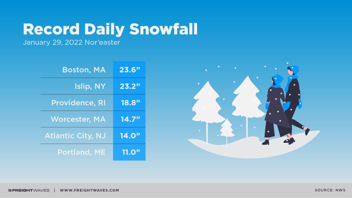
Last weekend, a powerful winter storm slammed parts of the Northeast and mid-Atlantic. For many places, it was the first major snowfall of the season. The nor’easter produced record snowfall in several cities for the date of Jan. 29, including Islip, New York; Boston and Worcester, Massachusetts; Providence, Rhode Island; Atlantic City, New Jersey; as well as Portland, Maine. Totals ranged from 11 to nearly 24 inches.
Winds were fierce last Saturday, gusting to 65 mph in Providence, 59 mph in Portland and 47 mph in Boston. Blizzard conditions made travel difficult and treacherous as visibility quickly worsened. The storm was so bad that transportation officials temporarily banned all vehicles from roads in some states.
2,000-mile storm
Another major winter storm that began Tuesday night produced heavy snow, as well as sleet and freezing rain, across a huge section of the country for more than two days. Impacts stretched from Texas to Maine, with daily record snowfalls for Feb. 2 and 3 in cities such as Chicago; Detroit and Flint, Michigan; Indianapolis; and Cleveland and Dayton, Ohio. Totals ranged from 5.4 to 11 inches.
The Dallas-Fort Worth International Airport was closed for several hours Thursday due to icy runways. Several small airports in the Midwest and Northeast either have been closed at times or grounded flights as the storm trudged along. Time spent de-icing planes led to significant delays, straining air cargo operations at FedEx, UPS and DHL. Before fading late Friday night in northern New England as it exits the U.S. heading for the Canadian Maritimes, the storm will likely bring icy conditions to the Interstate 95 corridor from around Philadelphia northward.
Dust in the wind
Some parts of the country, like the Desert Southwest, didn’t get buried in snow and ice this week. Instead, dry conditions and strong winds prevailed, kicking up fierce dust storms like this one in the Mojave Desert near Fort Irwin in southeastern California.
National Weather Service records showed that gusts ranged from 45 to 65 mph Wednesday across the deserts of southern Nevada and California and far western Arizona, with gusts of 60 to 80 mph in higher elevations of the San Diego and Los Angeles areas.
Beauty shot
This week’s beauty shot takes us across the pond to England, where a rainbow was spotted from an airplane between Duxford and Thruxton.
Click here for more FreightWaves articles by Nick Austin.
You might also like:
Worst 10 states for winter fatal traffic crashes
How costly were 2021 US weather disasters?
Historic floods ‘hammered’ British Columbia’s trucking industry