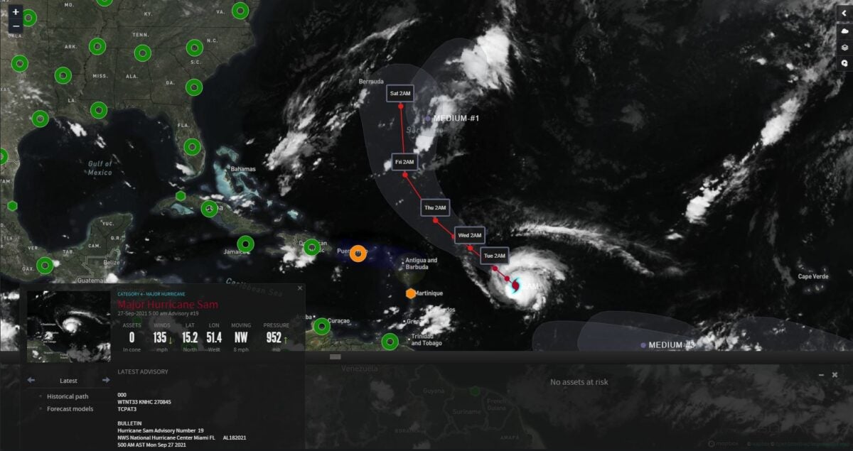
Hurricane Sam continued inching across the tropical Atlantic over the weekend, gaining strength in the warm waters.
By Sunday morning, Sam was a Category 4 hurricane with sustained wind topping out at about 150 mph. It’s nowhere near any land masses, but this could change later in the week.
As of early Monday morning, Sam was centered about 800 miles southeast of the northern Leeward Islands in the Caribbean. It was still a major hurricane with maximum winds of 130 mph, along with higher gusts, and the National Hurricane Center is forecasting Sam to remain a major hurricane (Category 3 or higher) for the next several days.
Even though Sam isn’t a big hurricane, its wind field has expanded. Hurricane-force winds still extend outward up to 30 miles from the center, but tropical storm-force winds were recorded up to 105 miles from the center, up from 90 miles away Sunday. Tropical storm-force winds in large hurricanes often extend 130 miles or more from their centers.

Swells generated by Sam will reach the Lesser Antilles Monday, impacting these islands through Wednesday or Thursday. These swells could cause life-threatening surf and rip currents, with potential minor issues at ports. A direct hit is unlikely as Sam remains to the north and east of these islands.
Sam will make big waves in some Atlantic shipping lanes, and container ship crews will have to steer clear. By the weekend, the hurricane may brush by Bermuda to the east, but it’s too early to tell if landfall is a possibility.
This is a developing situation. Look for updates on the FreightWaves website and social media accounts.
Related: How and why do hurricanes get their names?
Sam is the 18th named storm (tropical storms and hurricanes combined) of the 2021 Atlantic hurricane season, followed by Subtropical Storm Teresa on Friday (which has since dissipated). Over the past 30 years, the average number of named cyclones through Sept. 26 was about 10. This season to date has also had an above-average number of hurricanes (seven actual, five average) as well as major hurricanes (four actual, two average).
Also, Sam became the seventh hurricane of the season on Friday. The average date for the seventh Atlantic hurricane formation is Nov. 16 (the season officially ends Nov. 30), according to Philip Klotzbach, a meteorologist at Colorado State University who specializes in tropical weather. So, Sam is way ahead of schedule.
Other notable weather this week
Heavy rain will drench parts of the Northwest and Rockies this week, producing a few inches of high-elevation snow. Look for potential downpours later in the week from Texas to the Central Plains.
Major lanes of concern
• Interstate 5 from Mount Shasta, California, to Seattle.
• Interstate 15 from the Montana-Canada border to Dillon, Idaho.
• Interstate 90 from Missoula, Montana, to Seattle.
Windy weather Monday and Tuesday could spread some Western wildfires out of control and send smoke hundreds of miles away from these locations. This includes the two largest fires in the country: the Dixie and Caldor fires in California. Gusts from the south and west could reach 40 to 50 mph at times from the Sierra Nevada to the Reno-Carson City metropolitan area.
Major lanes of concern
• Interstate 80 from Truckee, California, to Reno.
Click here for more FreightWaves articles by Nick Austin.
You might also like:
Wildfire crews battling blazes — and supply chain kinks
Hours-of-service relief part of response to historic Minnesota drought


