


Update as of 8 a.m. ET Wednesday
Hurricane Idalia briefly intensified into a dangerous Category 4 storm early Wednesday morning before making landfall as a high-end Category 3 on Florida’s west coast.
The eyewall made landfall in the Big Bend area near Cedar Key and, as of 8 a.m. ET, the eye was located just inland from the coast.
In an alert Wednesday, the National Hurricane Center warned that storm surge of 12-16 feet could be expected between Wakulla/Jefferson County line and Yankeetown, Florida. Cedar Key was experiencing nearly 6 feet of inundation Wednesday morning.
The storm is moving quickly with north-northeastward motion of 18 mph. Fast storm motion is good news because it reduces the amount of accumulating rainfall, but it also carries the threat of stronger winds.
Idalia is maintaining winds of 120 mph around its eye wall this morning and hurricane-force winds (75 mph or greater) are being recorded up to 25 miles outside of the eye wall.
The center of the circulation is expected to be in southern Georgia by midmorning, where it will quickly weaken over the land.
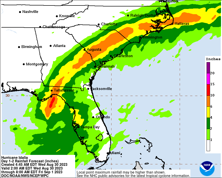
However, people from Tallahassee to the Outer Banks in North Carolina need to be prepared for flooding rainfall as the residual storm could drop anywhere from 6 to 10 inches of rain as it moves out over the Atlantic Ocean on Thursday.
In Georgia, vessel operations have been suspended until Thursday at the ports of Savannah and Brunswick. The captain of the Port of North Carolina declared port condition Yankee for Port of Wilmington and Morehead, North Carolina, on Thursday; that condition was expected to be upgraded to Zulu later Wednesday.
Update as of 5 p.m. ET Tuesday
The latest update from the National Hurricane Center (NHC) has upgraded Hurricane Idalia to Category 2 strength, finding sustained winds of 100 mph around the center of the storm.
The storm continues on a northward track, with rain bands impacting the southwestern coast of Florida and winds reaching the shores as well.
Measurements continue to find the storm gaining strength as it moves forward, and forecasters expect it to intensify into a major hurricane overnight.
Landfall is still expected in Florida’s Big Bend around midmorning Wednesday.
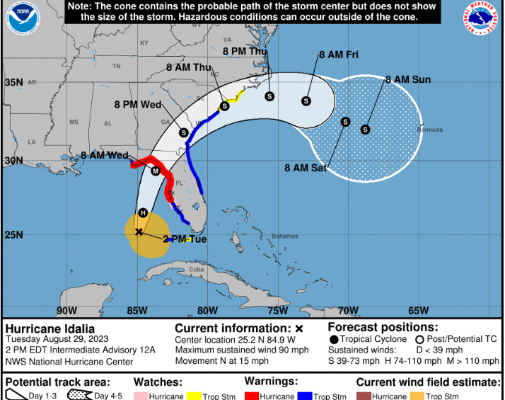
Update as of 2 p.m. ET Tuesday
Hurricane Idalia is still moving northward into the warm waters off the Gulf of Mexico, where it is expected to intensify rapidly this afternoon and evening.
Winds remain sustained at 90 miles per hour and the storm is still moving northward at 15 mph.
As of the National Hurricane Center’s 2 p.m. ET update, the center of the storm was located approximately 230 miles south-southwest of Tampa, Florida. Rain bands were starting to impact the Florida Keys.
All watches and warnings across Florida remain in place, including evacuation orders for residents in Tampa and St. Petersburg. The government of Cuba has let all hurricane warnings expire for its country.
The next National Hurricane Center advisory will be issued at 5 p.m. ET.
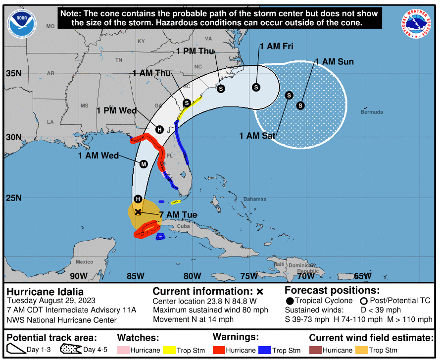
Update as of 9 a.m. ET Tuesday
Idalia strengthened into a hurricane overnight as it moved into the warm waters of the Gulf of Mexico. As of Tuesday morning, winds have increased to 90 miles per hour and the hurricane continues to move northward at a speed of 14 mph.
In an update early Tuesday, the National Hurricane Center said the storm will bring life-threatening storm surge, with some areas expecting 8-12 feet of water.
The storm is expected to undergo rapid intensification as it moves through the Gulf of Mexico and forecast models have it making landfall in Florida on Wednesday. The latest model data indicates the storm will become a major hurricane, potentially making landfall as a Category 3 with winds over 115 mph.
A state of emergency has been declared in 46 counties in Florida. Officials in Georgia, South Carolina and North Carolina are also monitoring Idalia for possible impacts.
A handful of counties in Florida have issued mandatory and voluntary evacuation orders for their residents ahead of the storm.
As the storm approached Monday, Florida’s seaports began to prepare for Idalia’s landfall.
The Coast Guard declared port condition Zulu for the Gulf Coast region, meaning that gale-force winds of 34 to 47 knots were possible within the next 12 hours due to the storm approaching Florida.
Gulf Coast facilities, including SeaPort Manatee — which is also at Zulu status — and Port Tampa Bay announced Monday morning they are closed to all inbound vessel traffic. The Coast Guard also declared port condition X-ray for the harbor at Jaxport on Monday but that is expected to be upgraded to Yankee by noon Tuesday.
The Tampa International Airport has closed operations as of Tuesday morning and expects to reopen Thursday after completing damage assessments.
This is a developing story.