Hurricane Laura crashed into the Gulf Coast overnight as a Category 4 storm, lashing southwestern Louisiana with 150-mph sustained winds.
“There will be parts of Lake Charles underwater that no living human being has ever seen before.” – Louisiana Gov. John Bel Edwards
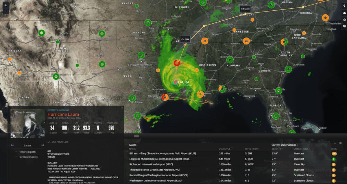
Laura — the region’s strongest storm in more than a century — made landfall near Cameron, Louisiana, around 2 a.m. CDT Thursday. By 5 a.m., the storm had weakened to Category 3 but was still producing powerful winds of 120 mph.
In Lake Charles, Louisiana, buildings shook as the winds howled. Roofs were torn apart, heavy objects blown over and hundreds of thousands of people without electricity, according to PowerOutage.US.
Water levels along the coast rose rapidly, and National Hurricane Center (NHC) forecasters warned of devastating winds and a potentially “unsurvivable” storm surge of up to 20 feet in some areas. Storm surge will remain a threat during high tide Thursday morning from southwestern Louisiana to the upper Texas coast.
“There will be parts of Lake Charles underwater that no living human being has ever seen before,” Louisiana Gov. John Bel Edwards told WWL Radio. “We are marshaling all of our people and assets to go in … and start a very robust search-and-rescue effort.”
It will be easier to assess the damage after sunrise.
Laura tied with a hurricane from more than 160 years ago for the strongest storm to hit Louisiana. The 1856 hurricane also had winds of 150 mph when it made landfall in Louisiana, according to CNN meteorologist Brandon Miller.
Laura was centered about 30 miles northwest of Lake Charles as of 8 a.m. Thursday, moving to the north at 15 mph. The NHC is expecting Laura to continue weakening as it moves farther inland.
The hurricane’s storm surge could spread up to 30 miles inland across southwestern Louisiana and far eastern Texas, reaching all the way to Interstate 10 between Beaumont and Lake Charles.
Rainfall totals of 6 to 12 inches through Friday, with isolated pockets of 15 to 18 inches, will add to the flooding threat in portions of Louisiana, Mississippi and Arkansas. Isolated tornadoes could also hit some of these areas.
Prior to the hurricane’s arrival, the Louisiana Department of Transportation and Development (DOTD) closed portions of I-10 in the southwestern part of the state.
Port Houston terminals will remain closed Thursday, while ports in Louisiana remain open with restrictions on vessel and freight movement.
United Airlines has suspended booking and movement of cargo at George Bush Intercontinental Airport until 11:59 p.m. CDT Thursday, and some truck stops in the hurricane’s impact zone may still be closed.