All ocean shipping, port and cargo operations remain shut at the world’s two largest dry bulk ports, Hedland and Dampier, owing to the passage of Severe Tropical Cyclone Veronica. Major liquefied natural gas export facilities along the north western Australian coast have also suspended operations. It’s the fourth consecutive day of suspended operations as Cyclone Veronica is moving very slowly. But there could be weeks of delay if Veronica soaks the landscape.
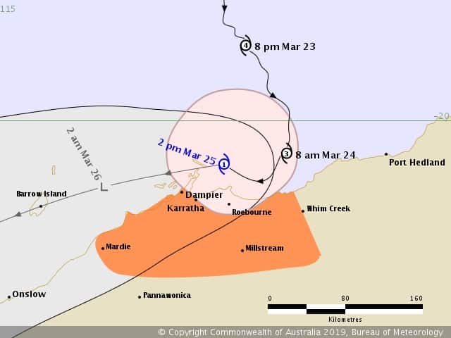
At the time of writing** the eye of the cyclone has not technically made landfall. The eye is just a little off the north west coast of Australia and is closer to Dampier, at about 71km (44.15 miles) distant, rather than Hedland which is 133.78km (83 miles away).
Veronica is bringing very strong winds and heavy rain, conducive to major flooding. Over 250mm of rain has been been recorded at Port Hedland so far.
Unfortunately, the cyclone, which is being described as slow moving by the Australian Bureau of Meteorology, has been “almost stationary” since Sunday morning. Destructive winds of 125 kilometers per hour (78 miles per hour) are being recorded along the north west coast and the Bureau adds that there have been wind gusts of over 100km/hour for over 24 hour along the coast.
“It’s often slower-moving cyclones like this that do greater damage because their impacts are felt for such a long time,” says Dr Adam Morgan, a meteorologist with the Australian Bureau of Meteorology in a public statement.
Looking at the cyclone maps, Port Hedland may have had a lucky escape. The forecast originally predicted that Veronica would make landfall between Port Hedland and the port at Dampier. However, cyclones are notoriously fickle and Veronica shuffled from side to side on its approach… putting Hedland in its path. Then, at about 20:00 hours March 24 (local time), the storm veered to the south east away from Hedland.

The port at Dampier may not be so lucky. Veronica is now forecast to move along the coast and that puts Dampier directly the path of the cyclone.
That’s potentially very significant as, according to the Bureau, the strongest (i.e. most damaging) winds are found within 50km (31 miles) of the eye of the storm.
Much of the population in the area affected by the cyclone are under a red alert – they’ve either evacuated, headed to shelters or they’re in some other safe place.
And that population, of course, includes various kinds of marine surveyors and auditors. So, at this point, the maritime industry does not know, and cannot assess, what, if any, damage has been done, how it was done and what it was done to.
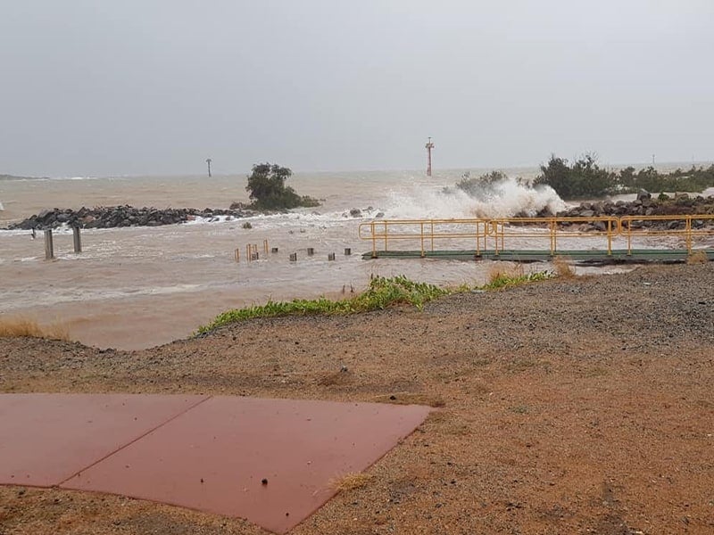
There are several potential damage points – local land-side and marine port infrastructure (ship-loaders, jetties, buoys and so on) can be damaged by wind or storm-surge. Port hinterland related transport infrastructure (road and rail) could potentially be flooded out and rendered impassable or, worse still, damaged or destroyed by flood waters.
And, finally, there’s the issue of dry bulk stockpiles getting wet. Wet iron ore is too dangerous to transport by sea – it can (and has) caused ships to capsize.
Moisture can be held in the spaces between touching iron ore particles in what appears to be a dry iron ore stockpile. During sea transport, the various motions of the ship, rolling, pitching, surging and so on, will cause the particles to separate. The moisture is then freed. The iron ore particles become suspended in water, which transforms an apparently dry cargo into a thick thick viscous mud or a freer flowing liquid mud.
Dry bulk carriers are not designed to carry gloopy liquids. As the ship rolls, surges and pitches, the liquid mud sloshes from side to side in the ship’s hold. It’s a lot of mud, and therefore weight, that’s moving around the ship. And the now semi-liquid cargo tends to shift in one direction and not return, which upsets the stability of the ship. If that happens for too long, and by too much, it will move the center of gravity in the ship. And the ship will list and could capsize.
Under the International Maritime Solid Bulk Cargoes Code a ship master must not load soggy dry bulk cargoes if it does not meet the Transportable Moisture Limit. That’s calculated from the flow moisture point i.e. the point at which the particles of the dry bulk cargo lose contact with each other and free the entrapped water. The Transportable Moisture Limit is 90 percent of the flow moisture point.
It’s certainly possible that the iron ore stockpiles will breach the transportable moisture limit. And here’s why: rain, tides and storm surges.

Data from the Bureau shows that there’s a lot of rain falling in the Dampier-Hedland region. Maritime executives also point out to FreightWaves that, owing to the time of month, the region is experiencing spring/king tides. As the moon circles the planet its gravitational pull on the waters of the Earth aligns with the gravitational pull of the Sun.
When that happens the planet experiences very high and very low tides. That’s significant. Spring tides will add another six to seven meters (20 to 23 feet) to the highest level of the spring tide. There was a spring tide on March 21. The neap tide (the lowest tide) is due several days from now. And the cyclone will bring a storm surge, which is a rise in the normal water level driven by higher winds and/or lower atmospheric pressure. It’s not known by how much higher Veronica’s storm surge will drive local tide levels.
Given spring tides plus a storm surge and it’s possible that the stockpiles will have been soaked from below in seawater as well as from above in rain water. After the weather event is over the water will drain from the stockpiles under the effects of gravity but how long that will take depends on a wide variety of factors such as the local drainage.
And that’s assuming that the iron ore stockpiles even survive Veronica, which they might not. Get enough water in the stockpile and the iron ore particles could lose contact with each other.
If that happens, the stockpile will liquefy and collapse. To then dry out the iron ore will require hot and dry weather with the use of machinery to repeatedly physical turn over the iron ore to encourage evaporation. Once the iron ore’s dry it can be re-piled. Maritime executives say that, in a worst-case scenario, it that could take up to 14 days to dry out the iron ore.

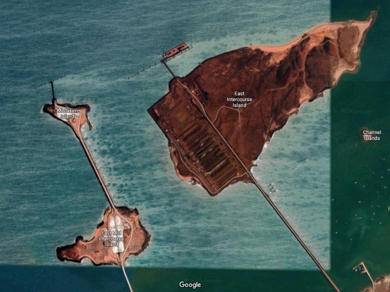
At least the iron ore won’t dissolve. The same cannot be said for the giant stockpiles on the export loading facilities of East-Mid-Intercourse Island and Mistaken Island at the Port of Dampier.
Those stockpiles are made of salt (see image, left).
“They’ll melt,” the executive said.
It’s also worth noting that the waters around Dampier are home to a solar salt-mining operation. A series of pens allow the progressive flooding then evaporation of seawater which leaves behind large volumes of sodium chloride i.e. table salt. When the final pan has salt in it to a depth of 25cm it’s harvested. The facility can make four million metric tons of salt a year. It takes 65 tonnes of sea water to make one tonne of salt. It takes 18-24 months to make the salt.
And if there’s heavy rain and/or a sea-surge then all of those pans will be flooded with water.
“So they’ll have to start all over again,” the executive said.
Maritime executives advise FreightWaves that they expect to start receiving assessments tomorrow mid-morning West Australia time.
From a maritime shipping perspective, the storm is significant as it has caused the temporary suspension of operations at Port Hedland, which handled 519.4 million metric tons of dry bulk throughput – the vast majority of which (98 percent) is iron ore.
Hedland also received 2,221 ships. As a metric ton is 2,204 U.S. pounds, Hedland’s volume equates to 572.5 million U.S. tons. It also caused the suspension of operations at Dampier which handled 177.3 million metric tons of cargo, of which 82.6 percent was iron ore for export, and 9,538 vessel calls.
Also suspended is Ashburton, a liquefied natural gas export facility that handled 2.6 million metric export tons in 2017-2018 and 90 vessels. Barrow Island, a significant West Australian oil and a 15.6 million tonnes per annum liquefied natural gas export facility operated by oil major Chevron, has also suspended operations.
**The time of writing is late Monday 25 March at 15:15 to 17:30 Australian Eastern Daylight Time; 12:15am to 02:37am U.S. Eastern Daylight Time and 21:15 to 23:37 U.S. Pacific Daylight Time.


