


A strong cold front will sweep across the High Plains and Great Lakes over the next two days, triggering severe thunderstorms and torrential rainfall in the Mountain Prairie and Midwest freight regions.
Severe storms produced golfball size hail and wind gusts of 70 to 85 mph in these regions yesterday. Severe storms continue to rumble in parts of the Dakotas and Minnesota early this today, August 14, with a second round likely coming this afternoon and evening.
This outbreak won’t be as destructive as the derecho that hit the Midwest Monday, August 10, but it will still produce some powerful storms. At least two people died Monday from wind gusts blowing down trees and rolling mobile homes.That storm produced winds of 80 to 90 mph in parts of Illinois.
Although this afternoon’s and evening’s storms will be in the form of an organized line stretching from north to south, some discrete supercell thunderstorms may develop, which could spawn tornadoes.
The National Weather Service (NWS) classifies a thunderstorm as severe if it produces any of the following based on radar, eyewitness reports or weather station measurements:
• Winds of at least 58 mph (50 knots).
• Hail at least 1 inch in diameter (quarter size).
• A tornado.
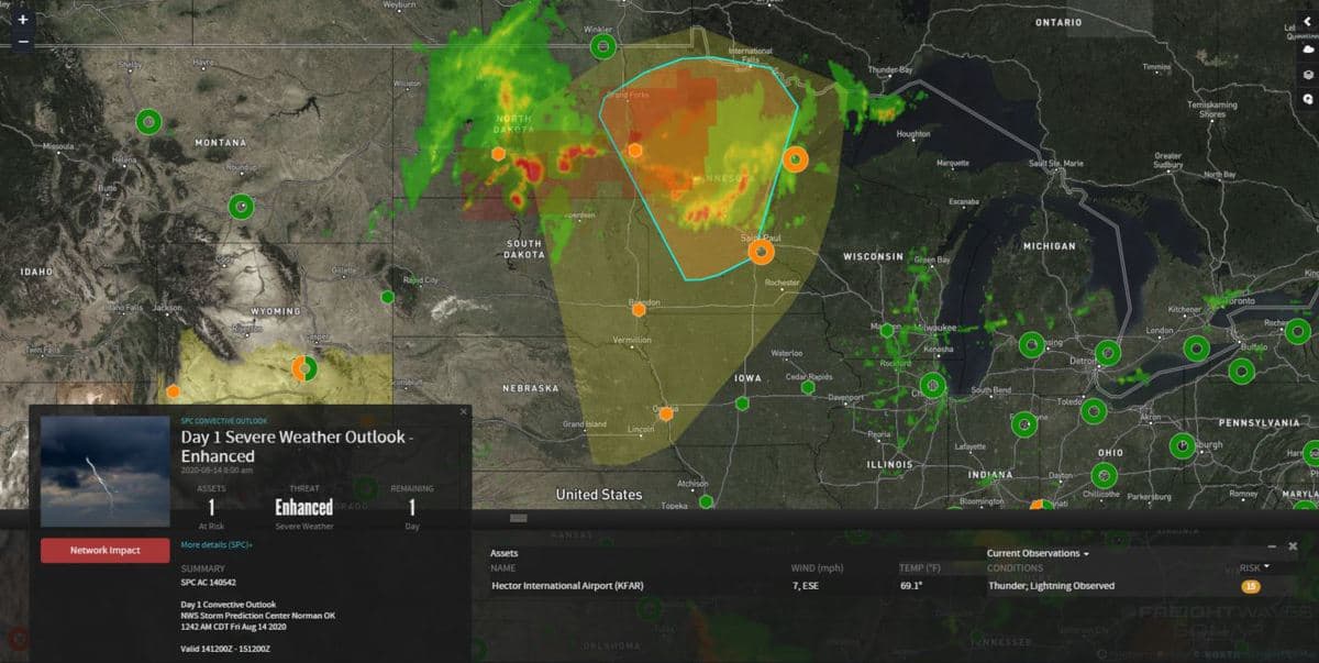
The best chance for severe storms will be from Minneapolis-St. Paul to Fargo and Grand Forks, North Dakota and along the North Dakota-Minnesota-Canada border. This will impact a large portion of Interstate 94. The Storm Prediction Center (SPC) has placed these areas under an “enhanced” risk, meaning severe storms could be numerous and persistent across these areas.
Severe storms could also strike places like Bismarck, Omaha, eastern South Dakota/northwestern Iowa, southern Minnesota and northwestern Wisconsin. These may impact I-29, I-80 and I-90. These areas are under a “slight” risk, meaning severe storms will be scattered and won’t last as long as storms in the “enhanced” risk locations.
Friday’s storms may also produce heavy rainfall and flash flooding in some spots.
The severe weather threat shifts eastward Saturday to the Great Lakes, but severe storms should be very isolated and the tornado odds low.
Other weekend weather
Slow-moving storms could produce periods of torrential rainfall from the southern Appalachians to the mid-Atlantic Saturday and Sunday. Drivers may run into roadblocks or ramp closures on I-81 and I-95 due to flash flooding. This potentially includes the Baltimore, Washington, D.C., Philadelphia and New York City metropolitan areas.