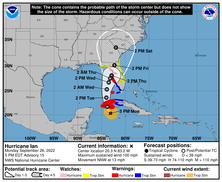
Update as of 5 p.m. ET Monday
The National Hurricane Center has upgraded Hurricane Ian to a Category 2 storm as of the 5 p.m. EDT advisory Monday evening.
Ian was located approximately 150 miles south of the western tip of Cuba with sustained winds of 100 mph and a northward forward speed of 13 mph.
The Dry Tortugas west of the Florida Keys have been upgraded to a hurricane warning as the storm moves northward. The Tampa Bay area in Florida has been upgraded to a storm-surge warning with the highest potentially reaching 10 feet.

Residents of Cuba are being told to prepare for strong winds, heavy rainfall, flooding and possible mudslides through the next 24 hours as the storm moves over the western part of the island.
Ian is expected to reach major hurricane status Monday night or during the early hours of Tuesday morning and remain at least that strong until landfall later this week.
Update as of 2 p.m. ET Monday
Hurricane Ian, now a Category 1 storm with wind speeds of 80 mph, was impacting the Cayman Islands Monday afternoon. The storm is centered just to the south of western Cuba with the outer bands starting to bring light rain and winds to the island.
The National Hurricane Center has forecast Ian to continue on a north-by-northwest track and currently measures its forward speed at 13 mph. The forecast track has Ian making U.S. landfall just north of the Tampa Bay, Florida, area by the end of the week, but the exact location is still uncertain.
With the shift to the north/northwest, the storm surge risk increases for the Florida Peninsula as it will sit directly to the east of the central circulation of Ian. This also puts the western Florida coast in a bull’s-eye of heavier rainfall, as the heaviest rain typically occurs on the east side of hurricanes.
If the storm makes U.S. landfall in Tampa, it would be the first landfalling hurricane to hit that area in over 100 years.
Forecasts have the storm strengthening to Category 2 by Monday afternoon. Rapid intensification is expected as Ian gets closer to Cuba, with major hurricane status (Category 3 or stronger) expected by late Monday.
Currently, there is a hurricane warning in place for Grand Cayman and several provinces of Cuba. A storm surge watch is in place from the Florida Keys up through Tampa Bay; Tampa and St. Petersburg are also included in a hurricane watch.
Hillsborough County has issued mandatory evacuation orders for the coastal parts of Tampa and you can find those detailed evacuation zones here. Collier County, Florida, is under a voluntary evacuation order. You can keep up with the latest evacuation orders for Florida here.
Florida Gov. Ron DeSantis has activated the state to level one preparedness for the storm, which includes mobilizing 2,500 Florida National Guard members into preparation mode.
The next comprehensive advisory from the National Hurricane Center will be issued at 5 p.m. ET. Find the public advisory updates here.

Artemis I launch delayed by Hurricane Ian
With the storm headed toward Florida, NASA on Monday announced it will roll back its Space Launch System (SLS) to the Vehicle Assembly Building at Kennedy Space Center in Merritt Island, Florida.
The rocket was scheduled to launch Tuesday, but increased concern over the incoming storm and the safety of NASA personnel forced the agency to postpone the mission and secure the rocket. The rollback is expected to start at 11 p.m. EDT Monday.
“NASA has continued to rely on the most up-to-date information from the National Oceanic and Atmospheric Administration, U.S. Space Force and the National Hurricane Center throughout its evaluations and continues to closely monitor conditions for the Kennedy area,” the agency said in a statement.
NASA previously scrubbed its Aug. 29 launch — and again on Sept. 3 — due to a hydrogen leak found in a quick disconnect fuel-feed line. On Wednesday, the agency conducted a cryogenic demonstration test to address the issue.
NASA has yet to say when the SLS will return to Launch Pad 39B for its next attempt.
— Compiled by Jeremy Kariuki
Updated as of 2 p.m. Sept. 25
Tropical Storm Ian has formed in the Caribbean Sea, just south of Jamaica, with maximum sustained winds of 45 miles per hour.
Ian is expected to remain over the ocean until early Monday morning, where it is then forecast to become a major hurricane before it moves over the island of Cuba and into the Gulf of Mexico.
On Saturday, Jamaica was under a tropical storm watch and the Cayman Islands were under a hurricane watch. The National Hurricane Center said the storm could bring heavy rainfall and flash floods to those areas in the coming days.
The Gulf of Mexico is the perfect environment for rapid intensification of this storm, as the sea surface temperatures are very warm. And as Ian moves into the Gulf on Tuesday, it has the potential to gain strength very quickly.
Uncertainty is still very high for where Ian will make landfall in the United States, but people in Florida from the Big Bend region down to the Keys need to start making preparations in anticipation of the storm’s arrival.
Ahead of the storm’s arrival, Florida Gov. Ron DeSantis declared a state of emergency for 24 counties in the state and urged residents to be ready.
“This storm has the potential to strengthen into a major hurricane, and we encourage all Floridians to make their preparations,” he said in a statement. “We are coordinating with all state and local government partners to track potential impacts of this storm.”
Ian joins active storms Fiona, Gaston and Hermine in the Atlantic Basin.
For detailed forecast information, keep up with the National Hurricane Center here.


