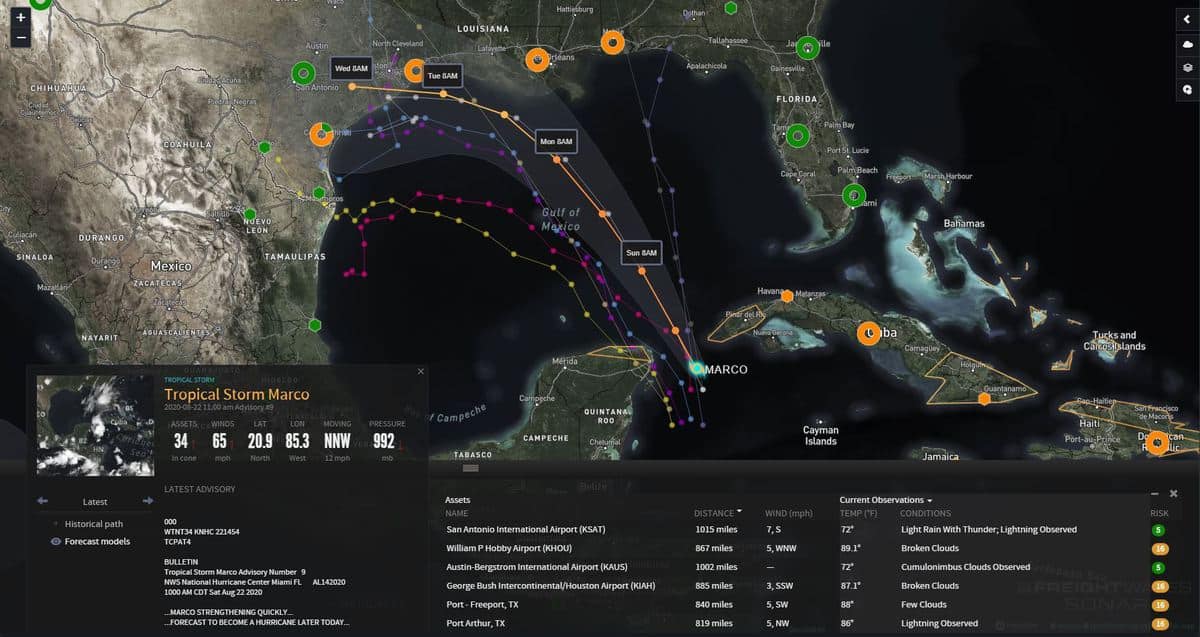
Tropical Storms Laura and Marco continue to gain strength Saturday and are expected to hit the Gulf of Mexico early next week.
Nick Austin, director of weather analytics and senior meteorologist for FreightWaves, said this is a rare occurrence and has only happened two other times in recorded history.
“The last time we had two named storms, either hurricanes or tropical storms in the Gulf of Mexico at the same time was back in 1959,” Austin said in a special weather update Saturday morning. “The first time was in 1933.”
In its 2 p.m. update on Saturday, the National Weather Service (NWS) stated that Tropical Storm Marco, which is currently moving through the Yucatan Channel, is expected to strengthen today into a hurricane and move into the Gulf of Mexico on Sunday. Its maximum sustained winds are around 65 miles per hour.

“There are increasing risks of storm surge, heavy rain and winds from the upper Texas coast to Louisiana early next week and watches may be issued later today,” according to the NWS.
Tropical Storm Laura is gaining strength near Puerto Rico with maximum sustained winds of 50 mph on Saturday. Austin said Puerto Rico, as well as parts of the Dominican Republic and Haiti, will get slammed with heavy flooding rainfall and high winds through the weekend.
Laura will hit parts of the Bahamas and Cuba later this weekend and into the first part of next week, Austin said.
“As Laura heads toward the Gulf of Mexico on Tuesday, it’ll likely strengthen into a Category 1 hurricane as the waters are very warm in the Gulf,” he said.

Austin said Laura is expected to hit between Galveston, Texas, and Mobile, Alabama, sometime Wednesday.
Louisiana Gov. John Bel Edwards declared a state of emergency Friday night, as both tropical storms barrel toward the Gulf of Mexico.
“Louisiana is in a unique situation in that it is in the cone of two storms, which could impact different areas of the state in the coming days,” Edwards said in a statement. “It is too soon to know exactly where, when or how these dual storms will affect Louisiana, but now is the time for our people to prepare for these storms.”
The U.S. Coast Guard closed ports in the Virgin Islands and Puerto Rico on Friday because of Tropical Storm Laura.
“This means all vessel traffic and cargo operations are suspended until the storm is far enough away that it’s not a threat anymore,” Austin said.
On Friday, Craig Fuller, chief executive officer of FreightWaves, offered advice to truckers about what to look out for when hauling FEMA loads on WHAT THE TRUCK?!?
Nick Austin, director of weather analytics and senior meteorologist, contributed to this report.
Read more articles by FreightWaves’ Clarissa Hawes
Don’t forget: CVSA’s Brake Safety Week starts Sunday
FreightWaves CEO: What to look out for when hauling FEMA loads
Inspectors to focus on driver requirements during 72-hour blitz


