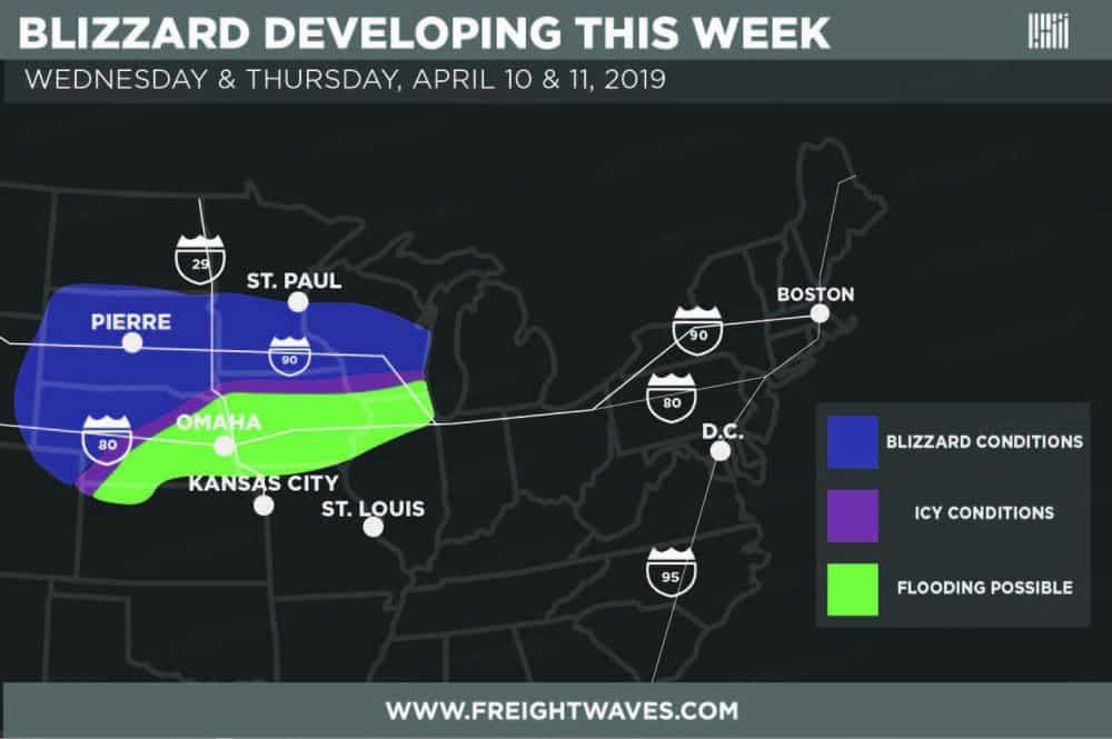
Like a bad rash that just won’t go away, winter is hanging on across the nation’s heartland, despite the fact that spring is almost a few weeks old. A storm will move out of the Rockies Tuesday night, becoming more intense as it moves eastward across portions of the Great Plains and the Midwest from Wednesday through Thursday. These are regions of the country that have already been punished by blizzards and record snowfall this year.
From the Black Hills of eastern Wyoming to the prairies of southern Minnesota, many areas could get socked with 10 to 15 inches of snowfall when it’s all said and done, as well as blizzard conditions with winds howling to 40 or 50 mph. For truckers, deadheading will be very risky. Also, blowing snow will severely reduce visibility, and the powerful winds could knock out power to many neighborhoods.
The storm will start to gain strength on Wednesday from eastern Wyoming into South Dakota and northern Nebraska. Road conditions will deteriorate on the I-25 and I-90 corridors, as well as countless U.S. and state routes. Some cities in the path of this high-impact storm are Casper, Mount Rushmore, Rapid City, and Sheridan. Some heavy snow will also spread into southern Minnesota on Wednesday. To make matters worse, a narrow band of freezing rain and icy weather could develop from central Nebraska all the way to southern Minnesota and far northern Iowa, making a mess on I-29, I-35 and I-90 through these areas.

The storm shifts to the east on Thursday, but not by much. With warmer air heading northward, snow and ice in parts of the Midwest will turn to rain. But plenty of snow will keep falling in other areas, and winds won’t let up. The storm finally fades Thursday night into Friday, but the damage may stick around for days.
Although eastern Nebraska (including Omaha) and western Iowa will be spared from the blizzard, people there will suffer an unfortunate downside of this storm – heavy rain. It could lead to renewed trouble along the Missouri River in areas where water had finally been receding after last month’s historic floods. Once the snow from this storm melts further north, flooding could also get worse along the Big Sioux and James Rivers in Iowa and South Dakota.
The National Weather Service (NWS) has issued Winter Storm Watches for all the areas previously mentioned, and may add more. The NWS will then likely change these to the more serious Winter Storm Warnings as the storm evolves. Use this interactive map for the latest official winter weather alerts, and check chain laws here for the latest updates on winter driving. Also, look for weather updates on the FreightWaves website.


gklzlyuejl
lthdjblnmvxbdtfjtrrxwkwjgqdhzd