People in parts of the Midwest who were frozen over from last week’s arctic outbreak have been enjoying a nice thaw for the past several days. But things are about to take a turn for the worst once again. Another harsh winter storm is about to pump bitterly cold air back into the region, along with areas of snow, ice and strong winds.
Development and Timing
The jet stream – a “ribbon” of constantly flowing air in the upper atmosphere that steers weather systems – will push a storm from the Rockies into the Midwest from late tonight (Wednesday, February 6) through Thursday. The storm’s intensity will increase along the way.
Tonight, mainly after midnight, areas of freezing rain and sleet will develop from near Tulsa, Oklahoma all the way to southern Wisconsin and lower Michigan, just missing Chicago and Detroit. Meanwhile, heavy snow will fall from Omaha, Nebraska to Des Moines, Iowa.
The heavy snow will move into eastern Iowa (Davenport and Cedar Rapids) on Thursday, plus the Minneapolis-Saint Paul metro area, much of Wisconsin, as well as Michigan’s Upper Peninsula. At the same time, the threat for freezing rain and heavy sleet shifts to eastern Wisconsin (including Green Bay and Milwaukee), and spreads further northward through lower Michigan.
Precipitation should gradually fade Thursday evening, but the storm won’t be done then. Stiff northwesterly winds will create blizzard conditions in some areas, and the region will stay very cold for a few days after the winds calm down.
Snow and Ice Amounts

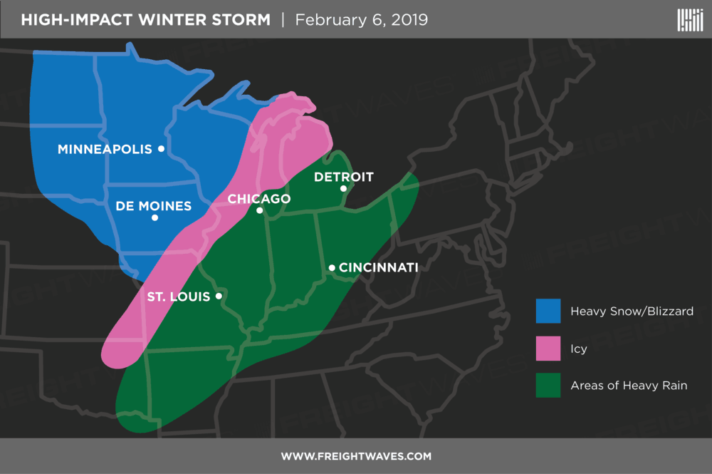
In the pink-shaded area on the map above, the thickness of ice build-up will depend on surface temperatures at various locations. Accumulations could approach one-half inch in some towns, weighing down trees and power lines, potentially knocking out electricity.
The biggest snow totals will probably be in Michigan’s Upper Peninsula, where 10 to 15 inches could pile up in Marquette, as well as from Houghton to Copper Harbor on the Keweenaw Peninsula. Another area of the Wolverine State that may get hit hard with snow is from Ishpeming to Three Lakes, in the area known as the Michigamme Highlands. Parts of Wisconsin (Appleton, Rhinelander, and Wausau) could see up to eight inches of snow, in addition to the I-29 corridor along the border of Minnesota and the Dakotas.
Winter weather alerts from the National Weather Service (NWS) are constantly being updated as storms evolve. Look for the latest changes on this interactive map. Also, check chain laws here for the latest updates on winter driving.
Wind and Cold
Over a distance of almost 1,000 miles, a big pressure difference of about 40 to 50 millibars will set up between the center of the storm (low pressure) and the high pressure that will replace it. This will create strong winds, blowing snow and possible whiteout conditions in the blue-shaded area on the map. Another side effect will be extremely cold wind chills of 30 to 40 degrees below zero from Fargo and Grand Forks to International Falls. Frostbite can set in quickly in this environment, so please stay indoors as much as possible. Wind chills will dip to 25 below zero in parts of Wisconsin and Michigan.
Impact on Freight

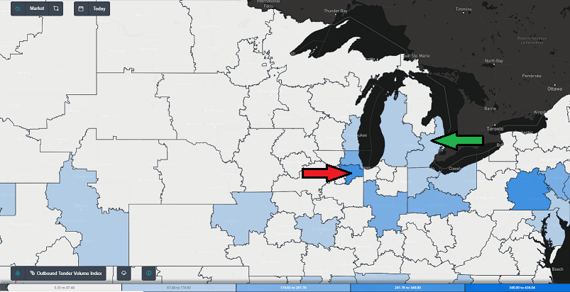
Looking at the latest FreightWaves SONAR numbers on the map directly above, many Midwest markets are enjoying moderate outbound volumes right now (shaded in blue) that shouldn’t suffer too much. Even though the storm will hit on a Thursday, typically one of the busiest days of the week for truckers, the high-impact weather will mainly occur in relatively stagnant freight markets (shaded in white). Disruptions in the supply chain should be fairly short-lived, too, since the storm will be in and out of the region within 24 hours, and high-population markets like Chicago (red arrow) and Detroit (green arrow) will likely be spared from icy conditions. Drivers, however, should be prepared for typical delays in other areas due to possible road closures or slow traffic.


