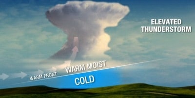
Usually when we think about thunderstorms we are reminded of warm, humid days. But every so often on a cold winter day, lightning strikes and thunder booms, like they did on Tuesday at FreightWaves headquarters in Chattanooga, Tennessee. Our neighbors just across state lines in northern Alabama and Georgia were amazed, too. Temperatures were only in the 30s when the storms rumbled, leaving a lot of people scratching their heads and wondering how this could happen on such a chilly February day. The answer is elevated convection.
Convection is a pretty simple concept in itself: warm air rises and cool air sinks.
In a stable atmosphere warm air rises, then it cools down and sinks, only to warm up and start rising again. In an unstable atmosphere, the air gets warmer with altitude, causing the air to continue rising (like a balloon) because warm air is lighter and more buoyant than cold air. That’s the convection we talk about in relation to thunderstorms, and also why warmer days are typically more favorable for thunderstorm development.
However, thunderstorms can form on cold days due to elevated convection. Instead of convection (lifting of the air) starting at the surface, it starts higher in the atmosphere, several thousands of feet up. But first, there needs to be a layer of air above the surface that is warmer than the surface itself. If that air gets warmer with height or is forced upwards by some atmospheric feature, then convection can occur. In yesterday’s case, the atmospheric feature that triggered the elevated convection was a warm front, which slopes upward. The result was thunderstorms! So, an elevated thunderstorm is one whose base is well above the ground.

Another way elevated convection can occur is when lifting and instability begin at the ground, but the air there is very dry. So, if the air gets a big enough push upward, it will become saturated and unstable. This can produce convective clouds and thunderstorms that have bases well above the surface, even though the lifting started at the surface
As they did yesterday, elevated thunderstorms can produce hail, in addition to very heavy downpours and flooding. They can also create strong downdrafts of air that come rushing toward the ground. Since the downdraft can have a significant distance to accelerate before reaching the surface, winds from elevated thunderstorms can be strong.
More storms and potential flooding are possible across the Southeast for the remainder of the week. Official alerts from the National Weather Service are available on this interactive map.


