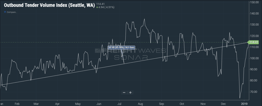
At the same time that outbound freight volume has increased dramatically, a messy, dangerous mix of wintry weather has come back to parts of the the northwestern U.S. today (Tuesday); other parts of the region will get their share starting tonight. Rain, snow, and freezing rain will make for slushy and slippery travel. Meanwhile, coastal areas will get hammered by heavy rain and wind. Freight movement out of the Seattle market may be delayed not just because of the weather, but because of an unusual surge in outbound loads since Christmas, as well as a major increase since a year ago, leading to more traffic on major routes.
Storm Development: Snow, Ice, and Wind
A strong low pressure system has been approaching from the Pacific Ocean today, pushing snow across the Cascades of Washington state and north-central Oregon, along with some pockets of freezing drizzle. This will continue tonight, spreading into the northern Rockies of Idaho and northwestern Montana, gradually fading Wednesday afternoon.
The heaviest snow will likely occur on the eastern slopes of the northern Cascades, slowing down travel on US-97 through Blewett Pass, US-2 through Leavenworth, WA-20 through Loup Loup Pass, Twisp, and Winthrop, as well as local routes through Conconully, Mazama, and Stehekin. Forecasts are calling for total snow amounts of three to six inches in the valleys, and six to 12 inches in the mountains, with a few spots exceeding 12 inches. With winds gusting as high as 35 mph over the mountains, drivers should be ready for periods of white-out conditions due to blowing snow. Spotty power outages are possible, too, as well as the potential of roads blocked by downed tree limbs or electrical lines.
Other parts of central and eastern Washington, like the Simcoe Highlands, Moses Lake area (between Spokane and Yakima), as well as the Wenatchee area, Okanogan Valley, and Waterville Plateau will get anywhere from two to seven inches of snow. But there’s an additional threat of freezing rain in these areas, so roads could become icy and quite dangerous, including sections of I-90. A glaze of ice, as well as light snow, is also possible in the Spokane metro area.
Snow and ice will also cause travel headaches along the I-84 corridor from just west of The Dalles, Oregon to the Blue Mountains. Two to four inches of snow will accompany a tenth-inch of ice.
Winter Weather Advisories have been issued by the National Weather Service (NWS) for the Cascades and eastern Columbia River basin. Also, you can check chain laws here for the latest updates on winter driving.
In addition, Winter Storm Warnings were just added early this evening for heavy snow above 4,000 feet in the Cascades. Snow accumulations of up to 3 feet are possible, along with wind gusts of 40 mph, at Paradise on Mount Rainier and over White Pass. A wintry mix of snow, freezing rain, and rain is expected in the valleys of Pierce, Lewis, Skagit, and Whatcom Counties.
Storm Development: Heavy Rain and Wind
Heavy rain will drench areas of the West Coast and adjacent mountain ranges tonight through Wednesday evening. Totals of two to six inches are likely from the Mount Shasta region and Eureka in California to southwestern Oregon. Thunderstorms could produce heavy downpours, leading to flooded streams and creeks along the I-5 corridor, as well as mudslides and rock slides. Drivers may run into areas of high water and shouldn’t try to move through them.
Also, powerful winds will peak tonight into Wednesday from San Francisco up the coast to the eastern Puget Sound area near Seattle. Some of the strongest gusts (40 to 60 mph) will slam the San Francisco coastal communities as well the tallest neighboring mountains and ridges. Winds could be just as nasty in the high terrain of northern California, from Eureka and Crescent City to Redding and Chico.
Winds could easily blow down large tree limbs and power lines which could block roads and knock out electricity.
Impact on Freight Movement

According to FreightWaves’ SONAR data, freight volume out of Seattle (OTVI.SEA) has dramatically increased since Christmas, which is unusual. This is normally a very slow time of year and volume often remains stagnant through February. Also, shown in the chart above, outbound volume from Seattle is 50 percent higher than this time last year, an incredible difference. So, carriers need to be aware there will be more traffic than usual coming from this area. No matter which direction they go from Seattle, drivers will likely be dealing with increased truck traffic along with the bad weather.


