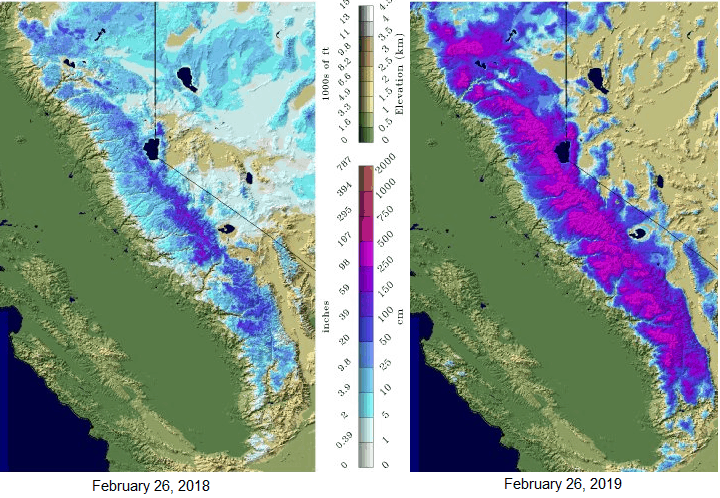
Let it snow, let it snow, let it snow! Skiers have been able to enjoy much more time on the slopes of the Sierra Nevada Range this winter compared to last season. Numerous storms have produced record snowfalls at many ski resorts, according to their owners. But, as is usually the case, this year has been tougher on carriers, as well as their drivers who haven’t been able to circumvent the region to deliver their goods. Delays are likely to slow them down again until this storm calms down in a couple days.
By the Numbers

The latest data from the National Oceanographic and Atmospheric Administration (NOAA) show a significant difference in current snowpack compared to this time last year. While coverage across the Sierra is only around 10 percent greater, the average snow depth across the region is nearly 6.5 times greater than a year ago, standing at 38.9 inches. The maximum depth today (Tuesday, February 26, 2019) is 223 feet at the Harkness Flat Snow Course in Lassen County.
The current storm, which shifted into high gear yesterday afternoon, has already dumped up to several feet of snow in some areas. These are the top five largest totals for the 24 hours from 10:00 a.m. PST Monday to 10:00 a.m. PST Tuesday:
• Castle Peak 40 inches
• Boreal Ridge Ski Resort 30 inches
• Soda Springs Resort 30 inches
• Sugar Bowl Village 28 inches
• Squaw Alpine Ski Rental 22 inches
Hannah Chandler-Cooley, a meteorologist with the National Weather Service (NWS) in Sacramento, told Freight Waves that there’s much more snow to come for the next 36 to 40 hours.
“An additional eight feet could accumulate at the peak of Lassen Volcanic National Park, which is around 10,500 feet above sea level,” said Chandler-Cooley.
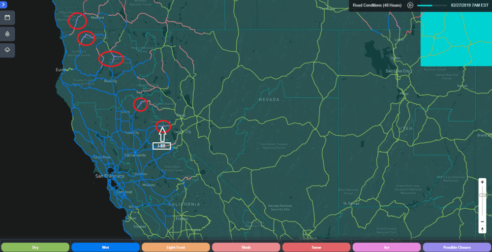
Donner Pass – just west of Truckee, California, and just a short distance south of I-80 – is forecast to receive another four to six feet of snow. This route is frequently used by truckers who need to haul loads from Nevada to northern California. Other heavily used roads such as US-50 over Echo Summit (south of Lake Tahoe), as well as CA-88 over Carson Pass, will get slammed with an additional two to four feet of snow.

Travel will be risky not just because of road conditions, but because of winds, too. Gusts may be strong enough to cause blowing snow and very limited visibility, as well as taking down trees and utility lines that could block roads. The winds will also make driving extremely dangerous for truckers carrying empty vans, which is known as “deadheading,”
“The storm may not be as strong in some areas on Wednesday, but it will still be impactful to travel,” added Chandler-Cooley. She also said this round of snow and wind should end by early Thursday (February 28), and updated alerts from the NWS can be found on this interactive map.
During this storm (and others), the California Department of Transportation (Caltrans) has occasionally closed portions of I-80 and other routes through the Sierras. More closures are expected. The storm will also make travel rough across the Mount Shasta region in far northern California, with heavy snow possible along the I-5 corridor north of Redding.
Rainy Days Down Below
While the high elevations of the Sierra and Shasta regions become snowbound, their lower slopes and foothills are expected to get doused with several more inches of heavy rain through Wednesday. Some drainage systems may not be able to handle the steady downpours, and some creeks and rivers could overflow their banks. The result would be flooded streets, mudslides and/or debris flows. Winds could be strong enough to knock down trees and power lines, so scattered power outages are a good possibility. These threats extend westward into the Central Valley (Redding to Sacramento to Modesto) and the San Francisco Bay metro area.
Please, be careful out there, and look for more weather updates throughout the week on the FreightWaves website!


