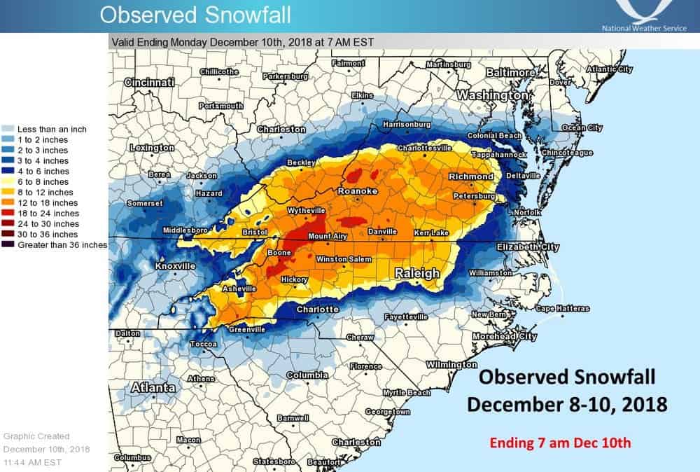
Hundreds of thousands of people in the South will have to deal with the effects of Winter Storm Diego the rest of the week, even after the storm ends tonight. The system dumped freezing rain and huge amounts of snow across portions of North Carolina, South Carolina, Tennessee, and Virginia over the weekend, and travel troubles will continue as a bit more ice and snow have accumulated today.
Unfortunately, at least three people including a truck driver have died so far in North Carolina as a result of the snowstorm. Keith Vestal, Yadkin County Emergency Services Director, told the Charlotte Observer that the driver got stuck along I-77 during the height of the storm on Sunday and was shoveling out. This happened about halfway between Boone and Greensboro. Shortly after shoveling, the man experienced chest pain, was taken to a hospital and pronounced dead. The man’s name hasn’t been released to the public as of this afternoon, but Vestal said that he considered it a storm-related death since the driver died of an apparent heart attack.
According to an Asheville Citizen Times report, one of the other two people who died was a terminally ill woman in Haywood County who passed away when her oxygen was cut off after the power went out in her home. She was under hospice care there. Also, in Mecklenburg County, a man died when a tree fell on him, according to North Carolina Emergency Management officials.
The North Carolina Department of Emergency Management and the State Highway Patrol tweeted earlier today that they’ve responded to several hundred collisions because of Diego, and more than 1,500 calls for service related to the storm. Officials are urging people to stay off the roads as much as possible not just for their safety, but for the safety of snow plow crews, power crews, and first responders.
Air travel came to a standstill when around 1,400 flights were cancelled on Sunday at the Charlotte Douglas International Airport. The Federal Aviation Administration reported delays today of up to one hour and 45 minutes at the Raleigh-Durham International Airport.
Snowfall records (measured in inches) for Sunday’s date, December 9, were shattered at the following airports:
-
Asheville (ICAO code: AVL): 5.3 (previous record was 2.0 in 1939)
-
Charlotte (ICAO code: CLT): 2.7 (previous record was 0.4 in 1989)
-
Greenville-Spartanburg (ICAO code: GSP): 2.8 (previous record was 0.7 in 1989)
-
Raleigh-Durham (ICAO code: RDU): 7.0 (previous record was 1.6 in 1989)
Greenville-Spartanburg also set a daily record of 1.5 inches for Saturday, December 8, beating the old record of just a trace of snow from 1997. According to the National Weather Service, anywhere from 12 to 24 inches of snow piled up from around Boone, North Carolina to Roanoke, Virginia.

Trees and power lines buckled under the weight of ice and heavy, wet snow across the region. As of 3 p.m. Eastern time today, PowerOutage.us reported more than 179,000 homes and businesses without electricity across the Carolinas, Tennessee, and Virginia. North Carolina got hit the hardest with more than 97,000 people still in the dark, followed by South Carolina with around 37,000, Virginia with nearly 36,000, and Tennessee with around 8,600. However, crews have been working hard and have restored power to almost half of these customers since Sunday.
Although the snow and ice has been melting in some areas, it could still be difficult hauling freight into and out of the region. Truckers will have to watch out for more icy spots on I-26 from Asheville to Spartanburg, and on I-40 and I-85 from Asheville and Spartanburg to Charlotte, Greensboro, Raleigh-Durham, and Winston-Salem. Black ice will be a major concern for at least the next two days, especially at night and in the early mornings when slush refreezes as temperatures drop into the 20s. Check for updates on North Carolina road conditions here and South Carolina here.


