Updated Sep. 13, 2021, 10:30 p.m.
The U.S. Coast Guard began setting port restrictions over the weekend to get ahead of Tropical Storm Nicholas.
Officials issued port condition X-Ray Sunday afternoon for the Port of Corpus Christi, Texas, and all other terminals and facilities due to the expectation of sustained gale-force winds. Late Monday morning they upgraded the port condition to Yankee for the Port of Corpus Christi from Rockport, Texas, to the Colorado River Locks in Matagorda, Texas.
Port condition Yankee is set when hurricane force winds will be possible. During port condition Yankee, all affected ports are closed to inbound vessel traffic greater than 500 gross tons. Vessel movement shall be restricted and all movements must be approved by the respective captain of the port.
For planning purposes, the port is closed during port condition Zulu, and all port operations are suspended. All vessels greater than 500 gross tons without permission to remain in port should have departed or be prepared to depart prior to the setting of port condition Zulu.
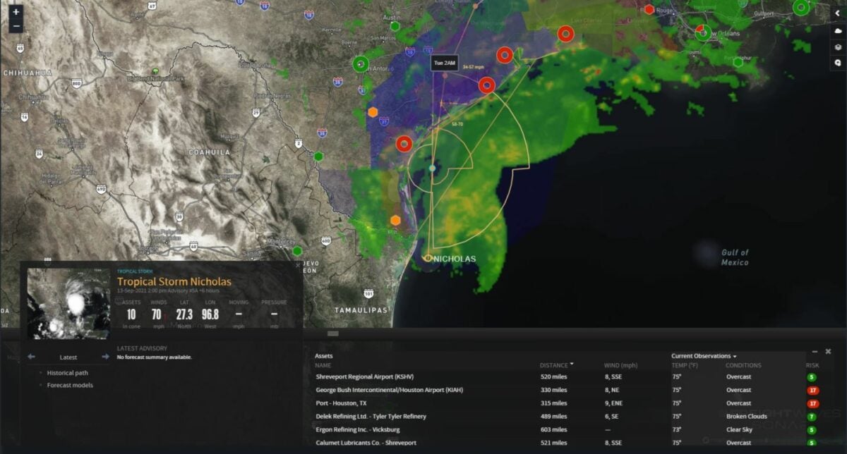
As of 11 a.m. EDT Monday, Nicholas was centered in the Gulf of Mexico about 45 miles northeast of the mouth of the Rio Grande River. Sustained winds were 60 mph with higher gusts, and tropical storm force winds (39 to 73 mph range) extended up to 115 miles from the center of the storm. A buoy located southeast of Corpus Christi recorded a sustained wind of 40 mph Monday morning.
Restrictions are also in place at the Port of Houston. Details are available here.
The National Hurricane Center is expecting Nicholas to strengthen, and the storm could reach the northwest Gulf Coast as a hurricane, making landfall Monday afternoon or evening near Corpus Christi. Then winds will weaken Tuesday and Wednesday once Nicholas moves over land.

Flood threat
While Nicholas may produce some wind damage and scattered power outages from the Texas coast to southwestern Louisiana, potentially major flooding is the bigger concern.
The heaviest rain will probably hit the Houston area Monday and Tuesday, with totals of 10 to 20 inches possible. Places just inland could see 5 to 10 inches. In southern Texas, the Corpus Christi area could receive 4 to 6 inches of rain, with locally higher amounts. Eight to 10 inches could accumulate from Beaumont, Texas, to Lake Charles, Louisiana, with some spots exceeding 10 inches.
The National Weather Service has posted flash flood watches for all of these areas. The heavy rain, along with 2 to 5 feet of storm surge, will make flooding inevitable in some locations.
Tropical alerts
• Storm surge warning from Port Aransas to San Luis Pass, Texas, as well as Aransas Bay, San Antonio Bay and Matagorda Bay.
• Hurricane watch from Port Aransas to Freeport, Texas.
• Tropical storm warning from the mouth of the Rio Grande River to High Island, Texas, and from Barra el Mezquital, Mexico, to the U.S.-Mexico border.
• Storm surge watch is in effect from the mouth of the Rio Grande River to Port Aransas, in addition to San Luis Pass to Rutherford Beach, Louisiana, including Galveston Bay, Baffin Bay and Corpus Christi Bay.
• Tropical storm watch is in effect from east of High Island to Sabine Pass, Texas.
Major lanes of concern

Interstate 10 from Houston to Lake Charles.

Interstate 69 from Houston to Harlingen, Texas.
Other notable weather this week
Severe thunderstorms could pop up Monday through Wednesday in places from the northern Plains to the Great Lakes and the Northeast. A few tornadoes are possible each day, but the main threats will be large hail and intense wind gusts exceeding 60 mph. Blinding rain and localized flash flooding are also possible.
Click here for more FreightWaves articles by Nick Austin.
You might also like:
Hours-of-service relief part of response to historic Minnesota drought


